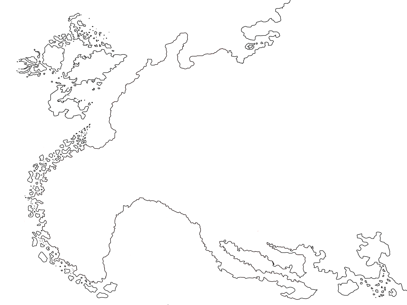
The Burus Mapping Project started back in 2016. I crafted the setting’s basics in an essay and subsequent written notes a few years prior, but aside from a quick and now lost sketch, I’d never attempted to make a map. The project would soon become stalled, but before being shelved I produced a basic outline of the continent:

I freehand drew the outline in Paint.NET, still my favorite raster graphics editor. I used Europe as a reference for scale and as a rough framework for geography. The cultural, historical and folkloric inspirations for my Burus stories — not to mention the derivative influences like Middle Earth, D&D, and much more — all have roots in Europe. My philosophy is that if those similarities are present in this constructed world, it aligns that the geography and climate being similar supports the whole.
That said, it’s far from a carbon copy continent. Burus drifts closer to actual Europe in shape than Tolkien’s Middle Earth, Warhammer Fantasy Roleplay’s Old World, or Robert E. Howard’s Hyborian Age north of the River Styx (also see this sketch from R.E.H.’s own notes showing how Europe aligned to the lands of his lost age before it). Each of the aforementioned constructed worlds inspired me with Burus, but I wanted to avoid the “stout peninsula” or “continental bump” approach they took. I used a bent tapering shape more in line with the real-world model instead.
Burus maintains the trope of a Left-Justified Fantasy Map as the others do. Guess I’ll just keep the tradition going on that one.
I worked off my essay for the Burussian kingdoms to establish the north and west coasts. But except for the southwest, my notes didn’t have anything to guide me on the layout of the southern coastline. I had nothing plotted down there yet. So I stuck to my “Europe as a rough framework” mantra and created an indented coastline featuring several long peninsulas. Burus deviates from Europe in lacking close landmasses past the seas of its north and southern coasts. A continent lies off the map to the south, but an ocean of water separates Memonon from Burus rather than a more navigable sea like the Mediterranean.
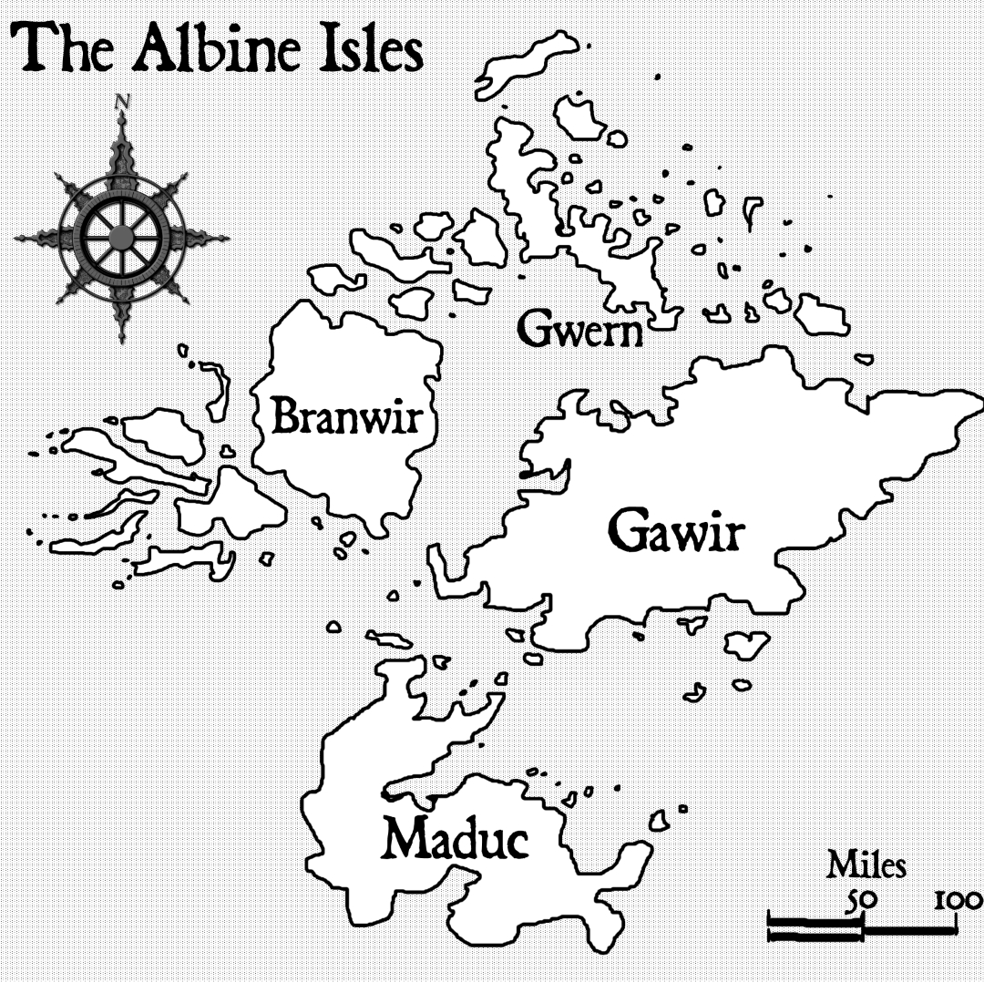
With the outline done, I zoomed-in and cropped the section with the Albine Isles, where my novelette The Brynesmark takes place, to create a regional map:
These two outline maps are as far as the project got in 2016. The task was daunting with the tools at hand, and I wanted to get back to writing. My attention got pulled away from Burus soon thereafter when a short story I’d begun crafting caught fire in my imagination. It takes place in an alternate history, urban fantasy setting of the late 1980s far removed from Burus. This became my first completed novel draft — Vivian’s Last Cigarette — in early 2017.
Viv’s got mired in editing and revisions, and I needed to take a break from the work. I produced some short pieces to clear my head with something different, and one of those in late 2017 grew into another novel draft — Shadow of the Black Tower. It evolved into having its own setting inspired by Robert E. Howard’s Hyborian Age and the works of H. P. Lovecraft after discovering that Howard’s Hyborian Age stories of Conan aren’t in the public domain as often claimed. Therefore, I rewrote the setting into a new original one, world of The Aeolian Age.
I continued working on Shadow into early 2019 until I got exhausted by the draft and many other factors. After a break, I shifted my focus to getting short works published as a lead up to finishing and releasing Vivian’s Last Cigarette. That started with Angel and Harvest in the fall of 2019. I’d planned for a host of my Burus stories to be published next, but production problems and revision woes pushed things out into the next year…
2020.
Like most people’s plans, mine too became sundered as I waltzed into 2020 and got hit by the 2020 bus. My workplace scraped me off the pavement next, and tossed me under the bus again with a pandemic layoff. The bus reversed over me and back again a few more times during the summer as the virus and politics pulled my country and family apart. In the fall, I lost a good friend who got on the 2020 bus ride and left this life. As the year closed, my last two aunts joined him. In the final days of December, I thought the bus had left at last. Then it sideswiped my father as a parting gesture. He died a day shy of the second week of 2021.
2020 was a hard year. 2021 hasn’t been easy either.
Anyway, that brings us to March of this year when I dusted off the Burus Mapping Project again. You can read more about that in my previous essay Concerning Fantasy Maps and Tolkien Cartography. The reason I came back to the project isn’t grand, I just felt strong enough to pick up the plan again and revise my Burus stories. I determined that a finished map of the setting would improve the revisions and aid them included with the books.
I’d never stopped adding to Burus by writing new pieces and revising old stories since I’d last attempted a map in 2016. Because of that, I knew that a second try on a map would be even more complicated. And from my previous frustrations and getting stalled on the project, I understood my need for a specialized art program. I can make a map with Paint.NET (or Inkscape, another favorite), but learning techniques and tools and getting to a presentable result would take a lot of time. The situation is comparable to saying that, yes, you can make a map with pencils and pastels… but it would be a lot quicker and easier with the specialized tools of a mapmaking kit.
In 2016 I couldn’t find a decent mapmaking program. There was Campaign Cartographer 3, a deep and complicated program. Also a decade out of date even then, having begun life back in the 1990s for role-playing game mapping. These were the days when no consideration went into ease of use or interfaces: It came with a nigh 400-page instruction manual, and you needed to devote the equivalent of taking several college classes before using the thing. Also, the maps created — while fine for personal use — are limited in terms of polish. They have a “1990s RPG video game map” aesthetic they can’t seem to shake. In the end, Campaign Cartographer didn’t meet the caliber I wanted for illustration in my books, and I regretted investing in the software.
Fast-forward to 2021 and things are different. While doing research to see if better tools existed after the intervening years, I found Wonderdraft… and everything I wanted.
Wonderdraft is a $30 program designed for fantasy cartography. Released around 2018, they made it for a core audience of RPG worldbuilders like Campaign Cartographer. But Wonderdraft’s interface is orders of magnitude more intuitive than Campaign Cartographer, and the program outdoes CC in every aspect that matters to me as a fantasy author making maps for their stories.
Other contemporary fantasy mapmaking software is also available today. Inkarnate is a popular example. What sold me on Wonderdraft was its customizable nature. You can purchase art assets for the program that are rights-free, or create and import your own. Rights with Inkarnate are murky, and a mix of free, limited and proprietary rights at best.
For someone making maps for only personal use, that would be an inconsequential point. But full rights are a major requirement for me or any author that plans to publish their map in their work. Besides, I wanted to create hand-drawn assets and literally leave my own personal mark on the map!
Despite an intuitive interface, there is a learning curve with Wonderdraft. If you’ve used a modern art program before, the basics will be easy to pick up. I do fine using the software with a standard mouse, but the program supports stylus input and works well with them. If you’re a more advanced digital artist than I am, you’ll breeze through learning Wonderdraft.
I’m not going to provide a tutorial on how to use the program, but you can find excellent walkthroughs and overviews here and here. There’s also an active Wonderdraft community on Reddit of discussions and map sharing. The subreddit is a great place to see the art made with the program and get inspired. A Wonderdraft Wiki exists as well, covering its technical aspects and how to set up customized changes to the program.
I purchased Wonderdraft the same day I discovered the software and got to playing with the program. In hindsight, I wish I’d let myself play a lot longer before getting to “serious work”. By having fun and exploring all the tools and what they could do, I would’ve built up my skills more ahead of jumping into mapping Burus. I was eager and excited to start, but I didn’t pick up on some matters of technique right away. That caused me frustration in the long run as some things came out inelegant and needed to be redone. Other things I did inefficiently when a much faster method or tool existed. So I recommend to any author planning to use Wonderdraft for mapping their setting to play around with the program for a day or three first. Focus on having fun and map a sandbox world or continent from scratch while enjoying all the toys. You won’t regret doing so.
Unprepared or not, on March 16th I imported my continental outline of Burus into Wonderdraft as an overlay and filled-in its contours:

And thus, the real mapping of Burus began.
Next, I’ll share my journey with the Burus map from its rough start above to being ready to label. Until then, take care, be safe, and keep writing!

Leave a comment